| SMLAC | ICTP Network Net-58 - IGCP Project 487 | |||||||
|
||||||||
|
Cities to be studied
(insert a map with indication of cities' location)
Cali, Colombia San José, Costa Rica Bayamo, Cuba Kingston, Jamaica Tijuana, México Lima, Perú Barquisimeto, Venezuela Cali, Colombia
Top
San José, Costa Rica
San José is located in the Costa Rican's Central Valley where more of the 70% of people, services and lifelines of the whole country are located. The subduction and shallow crustal seismic sources generate many felt earthquakes every year. The historical and recent seismicity have shown that important active faults exist near to the borders of the Central Valley and they could generate earthquakes as big as 6.5 degrees of magnitude. This scenario represents an important hazard to the cities placed on this zone. On he other hand, the soils in this area are un-consolidated (alluvial and volcanic deposits) and their thickness is sometimes bigger than 30 meters. There are many studies in the world which have confirmed that seismic waves suffer amplification effects due to this soil conditions. The situation mentioned before justify studies related to specific seismic fields in the area and will give us important tools to reduce the seismic risk and vulnerability.
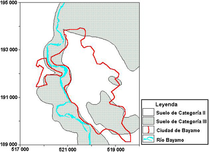
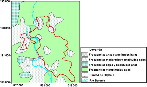
Bayamo, Cuba
Bayamo is one of the older cities in Cuba. It is located in a deep sedimentary basin, at about 60 Km of main seismogenetic zone in eastern Cuba (Oriente fault zone), but very close to secondary faults that may generate considerable big earthquakes. First report of heavy damage from earthquakes dates from 1551, and due probably to its bad fundament, the earthquakes occurred on Oriente fault zone, caused more damage that should be expected. Previous microzoning studies based on geological conditions (see figure), microtremors (see figure) measurements and in the use of soil-related attenuation relations and soil amplification factors to bedrock estimates have been done.
Top Kingston, Jamaica
Jamaica is a mountainous island in the north-central Caribbean Sea, situated between the deep waters of the Cayman Trough and the shallow shelf area known as the Nicaragua Rise. The rivers of Jamaica largely run southward and have created an expanse of Quaternary alluvial plains along the island's southern coast. Observations of the damage patterns of historic earthquakes over the past 325 years have linked the presence of these unconsolidated sediments to increased levels of ground shaking and devastation during strong and major earthquakes, and some areas have been known to liquefy. Thick sediment wedges together with the topography of the bedrock create basinal structures that cause focusing and interference of seismic waves, and result in severe amplification to varying degrees across the basin (Wiggins-Grandison et al., 2003, in press). Presently, close to 1,000,000 people or 35% of the Jamaican population reside on the Liguanea, St. Catherine and Vere Plains, on which the cities of Kingston (the capital) and Portmore, and the large towns of Spanish Town (the old capital) and May Pen, are located. In addition, these areas represent the commercial, industrial and economic lifelines of the country, with bauxite/alumina plants, most of the country's power generation facilities, major shipping ports, an international airport, a significant portion of the island's highway and railway infrastructure, sporting facilities and tertiary institutions. In present project it is proposed to study the city of Kingston with regard to microzoning by realistic modelling of surface waves.
Tijuana, México
Tijuana is a medium-sized city in northwestern México, pop. one million, with a large industrial and commercial infraestructure. It is located on a very heterogeneous topography, composed mainly of an alluvial plain, hills, canyons, and unstable slopes. Most of the poorest residential neiborhoods are located on high risk terrain. This city is located in the Southern California Shear Zone (SCSZ), a province associated to the Pacific-North American tectonic plates, characterised by large-scale, seismically active, right-lateral fault systems. At the Eastern margin of this region are located the southernmost segments of San Andreas, San Clemente, Brawley, Imperial and Cerro Prieto Faults; The California Continental Borderland is located west of SCSZ, and contributes to seismic hazard by the presence of the San Clemente, Coronado Bank, San Diego Trough, Rose Canyon, and Silverstrand fault systems; North of Tijuana is La Nación fault; South of Tijuana is the Calabazas-Vallecitos-San Miguel fault system. All of those faults are credible seismogenic sources imposing a major seismic hazard on Tijuana City. We have created a database for Tijuana, consisting of digital accelerograms, microzoning maps for dominant periods, shallow shear-wave velocities, shallow stratigraphy, seismic hazard predictive maps (expected PGA, PGV, PSA), and slope security factors. By means of the RADIUS project now we have a limited seismic scenario.
Lima, Perú
Lima is situated along the boundary of two tectonic plates, the Nazca and the South America ones, where, since 1585, it had been occurred 7 earthquakes with magnitude MS greater than 8, the last one in 1974. The seismic behaviour of this 7 million inhabitant city is highly influenced by soil conditions. It is placed in the big basin formed by the rivers Rímac and Chillón, and earthquake effects show great local variations. Previous microzoning works were made with real effects from past earthquakes; in particular, 1974 earthquake produced intensities in the city in a range as wide as V-VIII degrees of the MSK scale.
Barquisimeto, Venezuela
Barquisimeto, one of the most important cities of Venezuela, is located on the transpresive plate boundary between South America and the Caribbean, on which a right-lateral strike-slip of about 1-2 cm/year takes place. At local scale, this large city is sitting next to the Boconó Fault, which is responsible for destructive earthquakes in historic time, like the 1812 earthquake, which caused some 4.000 fatalities in Barquisimeto, Grases (1990). Today Barquisimeto is a fast growing city with over 1 Million inhabitants, expanding mainly over quaternary river terraces. Very few is known on the subsurface conditions, with outcropping schists in the eastern part of the town, where formal construction activity is concentrated, and terraces of unknown thickness in the west, where informal housing areas are fastly spreading.
Between 1998 and 2000, microtremor and seismic refraction surveys were carried out in Barquisimeto for the evaluation of ground shaking parameters (Rocabado et al., 2002). The predominant periods derived from H/V analysis vary between 0.2 to 1.1 s, with the values varying between 0.2 and 0.5 s east, of the city centre, where superficial P-wave velocities range between 1.000 and 2.000 m/s, corresponding to outcropping schists. Further to the west, predominant periods increase to average values between 0.5 and 0.8 s, corresponding to an increasing thickness of the sedimentary cover. From analysis of seismic refraction measurements and geotechnical drillings, characteristics were derived down to 15 m in the center of the town, with increasing thickness to the west. The sediments show an intercalation of stiff clay with sand and gravel, and the S- wave velocities range between 400 and 600 m/s. Acelerograms are available in analog form for moderate size earthquakes (magnitudes 3.9 to 5.3) for the region of Barquisimeto.
|
||||||||